


Research Update
Coral Reef Targeted Research & Capacity Building for Management
Over one-half
Coral
of the world's population lives
Reef
within 100 kilometres
Ta
T rgeted Research &
Capacity Building for Management
of the sea.
Remote Sensing Working Group
The role of remote sensing in supporting
coral reef management
W
Management Implications
1) Creation of decision-
o
The CRTR Remote Sensing
support and analysis software Build scientific capacity necessary R
Working Group (RSWG) is
for monitoring the health
kin
investigating the potential and
of coral reefs using remote
to provide the information needed
limitations of remote sensing of
sensing
G
coral reefs, so that the technology
for management and policy, so that
Until now, the remote sensing of
GR
may be used for realistic and
coral reefs has been conducted
practical management objectives.
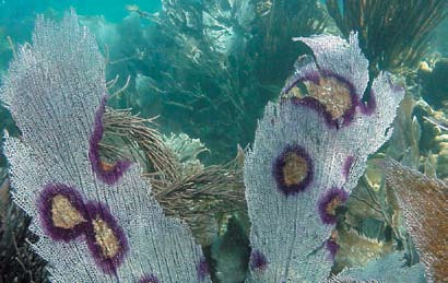
coral reef ecosystems under threat
on an ad-hoc basis with little
oup
The Working Group has identified
consistency or general insight
from climate change and multiple
four main areas of targeted
into its limitations. For example,
research.
we know that some aspects of
human stressors can be sustained
G
reef health can be resolved on
oal
shallow reefs in French Polynesia
for current and future generations.
but we cannot predict whether this
would be a realistic expectation
in say Jamaica, where reefs have
a different flora and fauna, are
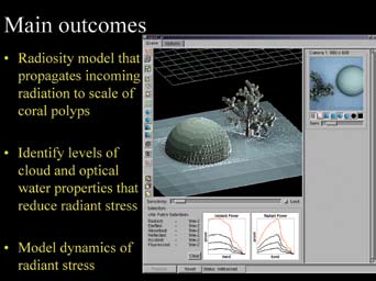
problem using radiosity methods
located in deeper water, and where which were originally developed
light penetration is slightly reduced in the computer graphic industry.
The Coral Reef Targeted Research &
because of higher suspended
Coral structures are divided into
Capacity Building for Management
sediment concentrations in the
thousands of individual patches,
Program (CRTR) is a leading
international coral reef research
water column. Without a generic
each of which behaves as a
initiative that provides a coordinated
understanding of the limitations
reflecting surface. On reaching
approach to credible, factual and
scientifically-proven knowledge for
of reef remote sensing, the
the reef, sunlight is reflected and
improved coral reef management.
technology may continue to be
scattered in predictable directions,
The CRTR Program is a proactive
oversold or deployed for unrealistic from which we can calculate the net
research and capacity building
management objectives, resulting
light recorded by the sensor once it
partnership that aims to lay the
foundation in filling crucial knowledge
in an inappropriate use of financial
has passed back through the water
gaps in the core research areas of Coral
resources.
and atmosphere. Computer models
Bleaching, Connectivity, Coral Diseases,
will be refined and tested in the
Coral Restoration and Remediation,
The RSWG will quantify the
Remote Sensing and Modeling and
laboratory and then tested under
Decision Support
limitations of coral reef remote
field conditions in a unique, large-
sensing by combining modelling
Each of these research areas are
scale remote sensing experiment.
facilitated by Working Groups
and field experiments. Models
underpinned by the skills of many of the
predict the ability of a given remote A series of platforms, approximately
world's leading coral reef researchers.
The CRTR also supports four Centers of
sensing instrument to detect the
3m by 3m in size, will be suspended
Excellence in priority regions, serving as
subtleties of bottom reflectance
at various heights above the sea
important regional centers for building
confidence and skills in research,
that distinguish reef habitats or the
bed. Objects will be placed on
training and capacity building.
cover of corals and macroalgae
these platforms to represent explicit
The CRTR Program is a partnership
within habitats. Whilst the passage
combinations of coral structure
between the Global Environment
of light through the water column
and various levels of reef health.
Facility, the World Bank, The University
of Queensland (Australia), the
is relatively well understood, the
Hyperspectral sensors will then
United States National Oceanic and
interaction of light between reef
be flown above the experiment
Atmospheric Administration (NOAA) and
approximately 40 research institutes &
organisms, many of which have
allowing us to replicate the
other third parties around the world.
complex structures, presents a
experiment under different levels of
October 2006
research challenge. We address this surface wind.
www.gefcoral.org


Research Update
Coral Reef Targeted Research & Capacity Building for Management
2) Development of methods
undergone the greatest change and
work that made use of community
to detect changes in the
help managers quantify the rate of
based mapping and storytel ing
coastal environment
change in reef habitats.
in central Java il ustrated the
difficulty that some cultures have
Remote Sensing is also needed
Three approaches wil be taken
with spatial constructs. Therefore,
to identify the habitat type and
to test the methods including (i)
one component of this study will
possibly predict the cover of corals
model ing spatial patterns of reef
build upon change detection of
and algae on a reef. This requires
substrata and simulating changes,
environmental status and attempt
high resolution imagery and direct
(i ) comparison of habitats within a
to determine the best cartographic
field survey at the time of image
sequence of images that have been
or narrative technique for
acquisition and therefore have
intensively ground-truthed (Belize,
communicating with local managers
limited application to archived or low- Mexico, Philippines, Australia, Palau), of coral resources.
resolution (30 m +) imagery. A wealth and (i i) the acquisition of images
of satel ite and photographic data are before and after an acute disturbance
often available for reefs, sometimes
event (e.g. bleaching event with high 3) Application of remote
archived as far back as World War
mortality) that occurs during the
sensing to the inventory,
II. We wil conduct a number of
project lifetime.
monitoring and management
activities to improve the way in which The communication of coastal
changes in reef condition can be
change can be difficult if using
of biodiversity
predicted indirectly using remote
a map-based approach in
Recent remote sensing research
sensing. These methods wil highlight communities that rarely use
has improved the detail of reef
which areas of the coast have
cartographic techniques. Previous
habitat maps but the interpretation
and uses of these products for
management has received relatively
little attention. Specifical y, what
do habitat maps mean in terms
of biodiversity and reef function
and how should they be used
for conservation planning? For
example, many reserve selection
algorithms require an extensive
database of species' distributions
which are costly and logistical y
difficult to establish. Remote sensing
could largely replace intensive
site-specific biodiversity surveys if
the value of habitats as a surrogate
for species (or functional) diversity
were established in a variety of
environments.
The CRTR Program provides an
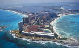
Aerial photog
unrival ra
e ph of hotel development in Cancun,
d opportunity for taxon omic
Mexico adjacent to coral reefs
capacity within its Centers of
© Wolcott Henry 2001
Excel ence and to quantify the
ecological basis of habitat maps.
The species composition of habitats
are being surveyed in Belize and
Mexico and compared and assessed
at a Caribbean-wide scale using
comparable data from the Bahamas.
Comparable surveys wil take place
in Palau and the Philippines but
with less reliance on species-level
identification. Emphasis wil be
placed on particularly important
species (e.g. commercial y-important
or `keystone' species) but much of
the species-level information will
be replaced with functional trophic
categories.
A second biodiversity activity is
quantifying the relationship between
the topographic complexity of reef
habitats (cal ed rugosity) and the


relative density of reef fish. Habitat
complexity is being measured using
acoustic remote sensing methods
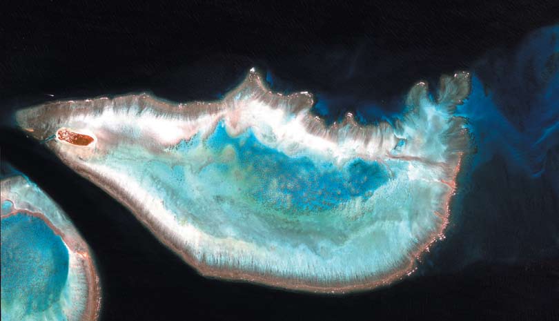
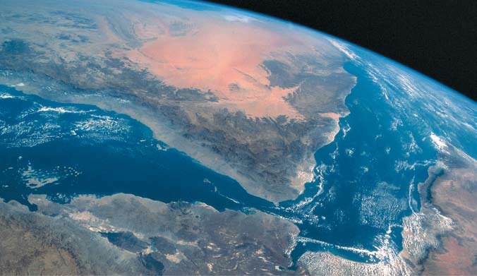
Satellite (IKONOS) image of Heron Island, Australia,
captured in April 2004, immediately following a period of
and related to the density and
coral reef bleaching. Heron Island is the small land mass
biomass of around 30 ecological y
(brown) to the bottom of the image, whereas most of the
and economical y important fish
living reef structre can be seen as light brown. Note the
species. Outputs of this research
living patch reefs (seen as small dots) in the center of the
image. The bright white dots surrounding the edges of the
wil enable managers to monitor the
reef are waves. The RSWG is using this and other images
effectiveness of reserves effectively
of coral reefs to determine the degree to which change
by stratifying their sampling by
detection may be possible over large areas.
both habitat type and local habitat
complexity, both of which affect the
densities of reef fish. Maps of habitat
complexity may also identify the
location and extent of critical fish
habitat which wil guide MPA site
selection and help understand the
connectivity of fish populations (e.g.
areas with high adult stocks or high
recruitment).
4) Creation of an Ocean Atlas
and tools to manage coral
bleaching
A wide variety of oceanographic
and atmospheric remote sensing
products are available for reef
management but many are in
disparate locations and user-
unfriendly formats. A variety of
US government agencies are
establishing a national Ocean Atlas
to collate a plethora of data sets
relevant for coastal management
within a single website. The RSWG
will extend this initiative to an
international Ocean Atlas for coral
reef environments. The website
will display a number of standard
environmental products (e.g.
wind speeds, wave heights, solar
Aerial photograph of hotel development in Cancun,
radiation) but also develop and test
Mexico adjacent to coral reefs
new products which are especially
© Wolcott Henry 2001
relevant to coral bleaching. Outputs
will (i) enhance the credibility of
managers by providing timely
spatial information (e.g. now-
casting mass bleaching events), (ii)
support reef research throughout
the Targeted Research Working
Groups, (i i) provide educational
and research tools by defining the
climatology of specific reef areas (iv)
enhance understanding of climate
change by recording and predicting
environmental trends worldwide and
(v) improve management of coastal
NOAA
watersheds through identification
of water quality dynamics. An
Allan Strong,
important aspect of this project is
that the Ocean Atlas wil be used by ving and
managers, scientists and students
interested in many other ecosystems William Skir
and parts of the World.
ge:
Ima
www.gefcoral.org


Research Update
Coral Reef Targeted Research & Capacity Building for Management
y
,
NASA Johnson Space Center
tor
bora
ysis La
Anal
ge
Earth Sciences and Ima
ge:
Ima
New sea surface temperature
Such models will be developed
products that predict temperature
and tested and after being merged
at sub-surface levels will begin in
with the outcomes of the CRTR
the first year of the project with
Bleaching Working Group, will
oup
principal development in Palau
enable managers to identify reefs
and Heron Island. However, the
which have a natural degree of
products will be tested and made
resistance to coral bleaching and
operational in all project sites
those that are most at risk. The
including Zanzibar. Solar products
creation of `bleaching risk maps' will
orking Gr
te
(short wave, PAR, UV) will begin
be pioneered by NOAA in Palau,
emote sensing in supporting
development in the second year
Heron Island and Puerto Morelos/
of the project, winds in the third
Belize and collaboratively with
upda
year, and turbidity in the fourth year the University of the Philippines at
depending on the availability of
Bolinao.
satellite data.
Aerial photograph of hotel development in Cancun,
Mexico adjacent to coral reefs
eef management
Coral bleaching is a major cause
© Wolcott Henry 2001
ole of r
of concern for the future of coral
reefs. The outputs from this project
Remote Sensing W
The r coral r - research
of an international Ocean Atlas for
coral reef environments will enable
managers to monitor the severity of
Further Information
environmental stress in the coastal
Remote Sesing Working Group
zone.
Chair: Professor Peter J Mumby
However, this cannot as yet easily
University of Exeter, United Kingdom
predict which areas are least likely
Email: P.J.Mumby@exeter.ac.uk
to experience conditions that
Co-Chair: Dr Laura T David
precipitate mass bleaching. Physical
University of the Philippines
Email: ldavid@upmsi.ph
models, based on hydrological
and tidal information, show great
Project Executing Agency:
potential for predicting how sea
Coral Reef Targeted Research &
temperature will vary across a reef
Capacity Building for Management
Program
system given a certain amount of
C/O Centre for Marine Studies
heating (i.e. which regions tend to
The University of Queensland
St Lucia QLD 4072
heat up fastest and which remain
Australia
cool).
Telephone: +61 7 3365 4333
Facsimile: +61 7 3365 4755
Email: info@gefcoral.org
www.gefcoral.org